The Blizzard of 1949 stands as one of the most severe winter events ever recorded across the Northern Plains. The initial storm struck with brutal intensity, beginning on January 2nd and lasting through January 5th. It unleashed a devastating combination of heavy snowfall, ferocious winds, and plummeting temperatures that immediately began to paralyze the region.
Subsequent storms battered the area through mid-February, piling snow into colossal drifts that made travel virtually impossible. Roads and railroads were buried and impassable, severing communication and supply lines to countless towns. In response, airplanes became a lifeline, essential for delivering vital food and medical supplies to isolated communities and, critically, hay to stranded livestock, which faced starvation in the deep snow.
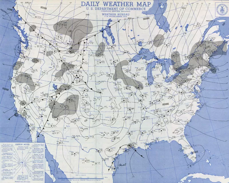 Weather map showing pressure systems and fronts over the central US on January 2, 1949
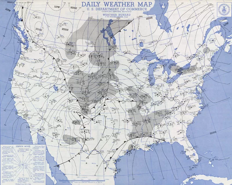 Weather map detailing conditions across the United States on January 3, 1949 during the early phase of the severe blizzard
The human cost of the blizzard of 1949 was significant across the affected states. While Western South Dakota reported one fatality, the storm claimed twelve lives in Wyoming, seven in Colorado, and twenty in Nebraska. These figures underscore the dangerous conditions faced by residents during this prolonged period of extreme weather (“Some Outstanding Blizzards”, U.S. Department of Commerce, Environmental Science Services Administration, Environmental Data Service, Revised December 1966).
Fred H. McNally, Meteorologist-in-Charge at the Rapid City Weather Bureau Office, described it as “the most severe blizzard in Rapid City history,” considering the combined factors of wind, snow, and temperature. The official average wind speed recorded at the Weather Bureau Airport Station (WBAS) near Rapid City reached 51.8 mph on January 3rd and an even higher 55.7 mph on January 4th. The highest recorded single mile of wind reached 73 mph, measured at an elevation significantly higher than current standards. Across the airfield, the Air Force Base Weather Office reported wind gusts exceeding 90 mph, adding a terrifying dimension to the storm’s power. Snowfall during the initial January 2nd-5th period varied widely but included depths of several feet in some areas. Temperatures across northwestern South Dakota plummeted well below zero degrees Fahrenheit.
January 1949 became the snowiest January on record for many observing stations in the Black Hills region. Snowfall totals for the month ranged from 12 to over 40 inches, an extraordinary amount representing three to eight times the typical January accumulation of four to eight inches. Despite brief thaws between storms where temperatures surprisingly rose into the 50s and 60s, it was also one of the coldest Januarys ever recorded, reinforcing the severe nature of the overall winter period.
The profound impact of the storm, particularly on the lives of those enduring it, has been documented in historical accounts. Harl A. Dalstrom and Kay Calame Dalstrom captured personal stories from South Dakota and Nebraska residents in their works: “It’s ‘Going Down in History’: The Blizzards of 1949” published in South Dakota History (1999) and “I’m Never Going to Be Snowbound Again: The Winter of 1948-1949 in Nebraska” in Nebraska History (2002). These narratives offer poignant insights into the challenges, isolation, and resilience experienced during this time. Another account was provided by Mr. Wayne Park, who arrived at Fort F.E. Warren Air Force Base in Cheyenne, WY, just as the storm hit, offering a perspective from those caught unexpectedly in its path.
The sheer magnitude of the blizzard of 1949 was powerfully captured in photographs by the Rapid City Daily Journal, documenting the landscape and the human effort to overcome the paralysis caused by the snow and wind.
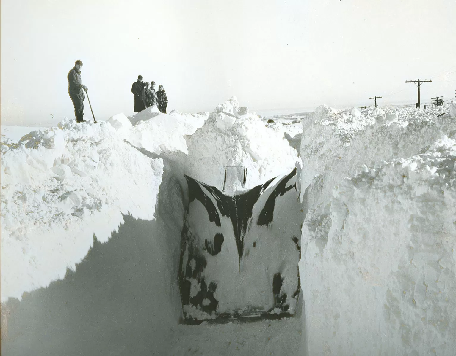 A railroad snowplow pushing through deep, ice-encrusted snow on the North Western line east of Rapid City, requiring dynamite to break up the drifts after the 1949 blizzard.
These images show the scale of the challenge, such as the railroad plow painstakingly clearing tracks, a task so difficult it required the use of dynamite to break through the ice-hardened snow. The scenes of downtown Rapid City reveal a community temporarily halted, streets lined with towering snowbanks, a visual testament to the storm’s overwhelming presence.
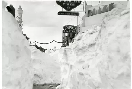 Downtown Rapid City blanketed in deep snow and quieted by the intense winter conditions following the severe blizzard of January 1949.
The blizzard of 1949 remains a significant event in the meteorological and social history of the Northern Plains. It highlights the raw power of nature and the enduring spirit of the communities that faced its wrath. The accounts and images serve as a reminder of a winter that tested the limits of human endurance and the resilience required to survive against overwhelming odds, a theme that continues to resonate and inspire reflection.
References
Dalstrom, Harl A., and Kay Calame Dalstrom. “It’s ‘Going Down in History’: The Blizzards of 1949.” South Dakota History 29 (Winter 1999): 263-326.
Dalstrom, Harl A., and Kay Calame Dalstrom. “I’m Never Going to Be Snowbound Again: The Winter of 1948-1949 in Nebraska.” Nebraska History 82 (2002): 110-166.
U.S. Department of Commerce, Environmental Science Services Administration, Environmental Data Service. “Some Outstanding Blizzards.” Revised December 1966.